Help
Introduction
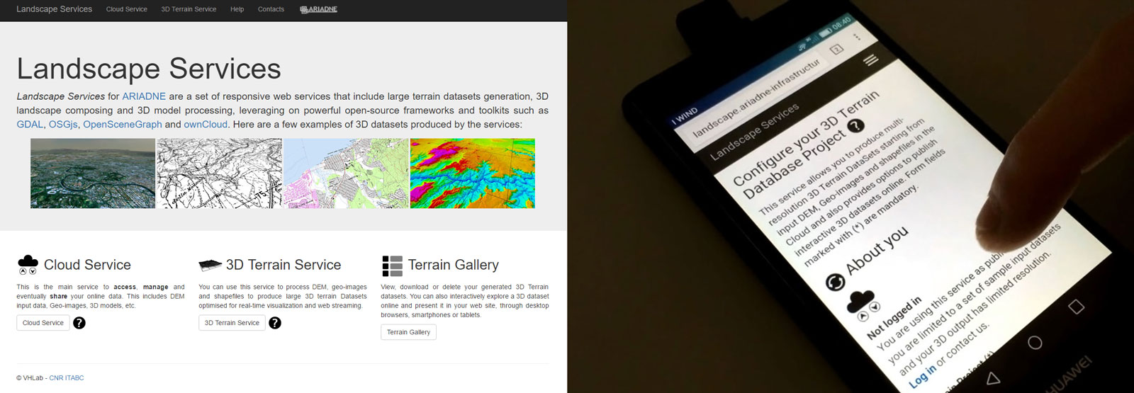
Landscape Services for ARIADNE are a set of online services focused on processing, management and publishing of large 3D interactive Terrain datasets within a collaborative workflow. The goals within ARIADNE infrastructure are:
- Aid and support 3D landscape reconstruction tasks and projects in Virtual Archaeology
- Provide online services for dissemination of interactive landscapes, through several devices
Technologies and Frameworks
Landscape Services leverage on server-side PHP, modern HTML5/Javascript capabilities and open-source frameworks and libraries such as:
- GDAL Libraries
- Virtual Planet Builder
- OpenSceneGraph framework
- OSG.js
- jQuery
Processing services leverage on robust paging mechanisms provided by OpenSceneGraph framework and Virtual Planet Builder with optimal scene-graph organisation of final datasets offering smooth interactive fruition on large terrain datasets. Each service is designed to be responsive and adapt where possible to the device needs (both desktop and mobile browsers). Online interactive fruition (WebGL) for multi-resolution datasets leverages on ATON Front-End, developed by CNR ITABC.
How to use the Services
This section will introduce each service and typical usage scenarios. You can also jump directly to tutorial sectionCloud Services
 Cloud service can be accessed as single users or whole
Research institutions to upload, manage and modify data involved in processing tasks (both input and output).
These services leverage on powerful customized ownCloud and allow great flexibility in terms of access policies, sharing and data distribution even among different servers. These services are optimized for desktop and mobile utilisation through HTML5 technologies, such as easy 'drag and drop' web-based interface, with full support for mobile and desktop clients.
Cloud service can be accessed as single users or whole
Research institutions to upload, manage and modify data involved in processing tasks (both input and output).
These services leverage on powerful customized ownCloud and allow great flexibility in terms of access policies, sharing and data distribution even among different servers. These services are optimized for desktop and mobile utilisation through HTML5 technologies, such as easy 'drag and drop' web-based interface, with full support for mobile and desktop clients.
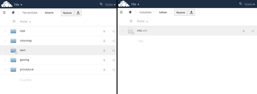
In a typical and comfortable processing setup, each project has its own folder into the cloud. Inside, sub-folders related to DEMs/DTMs,
geo-images and shapefiles are placed. For instance, a typical structure for a project named "MyTerrainProject" would be:
- MyTerrainProject/
- dems/ (required)
- geoimg/ (optional)
- shapefiles/ (optional)
3D Terrain Service
 The 3D Terrain service will provide users with tools to produce large 3D terrain datasets, optimized for real-time visualization and web fruition. A web-based responsive interface (HTML5 forms) will friendly expose server-side functionalities and allow user to define and control processing tasks.
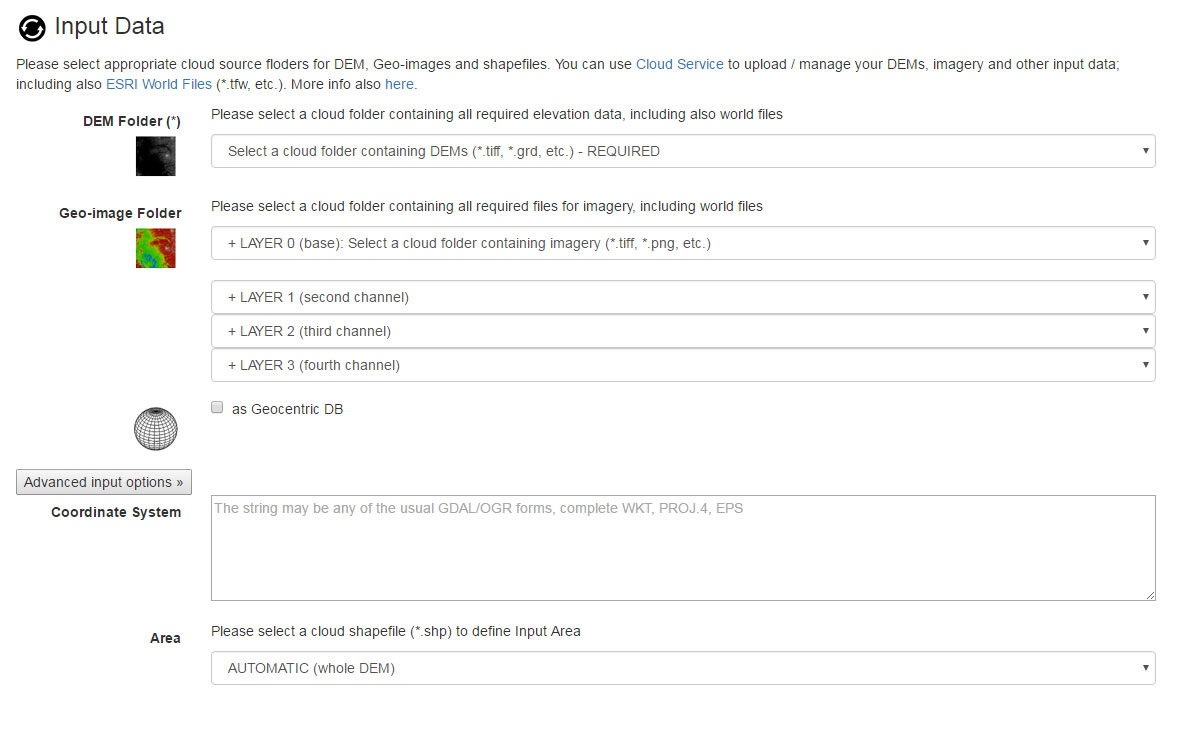
Input data (DTMs/DEMs, Geo-images, ESRI shapefiles, etc.) can be uploaded or managed through the Cloud Service
with protected access. Terrain web services will automatically list available input data and provide responsive web interfaces to
define the user task through customization of different parameters (database resolution, extents,
imagery attributes, etc.).
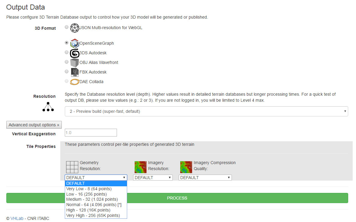
Several output options are offered, including JSON for interactive online fruition (WebGL, without plugins) or desktop 3D formats such as OpenSceneGraph native formats (optimized for real-time and web streaming), OBJ Alias Wavefront, 3D Studio Max, COLLADA and more. Web services will process data server-side and alert the user when 3D terrain dataset process has completed.
Video Tutorials
This is a series of short mini-tutorials, including:- Accessing Terrain service as public and generating a sample landscape (0:32)
- Accessing Cloud service, organization and publishing of multi-resolution terrains online (1:30)
- Gallery service to manage, download or delete your terrain DBs, sharing POVs on published DBs (2:41)
- 3D Annotations and multimedia content (3:11)
- Desktop 3D formats, HTML5 responsiveness and visualization on mobile devices (4:18)
FAQ
Q: Which formats can I use for DEMs/DTMs?
All formats supported by GDAL (*.tiff, *.grd, etc...).
Q: I uploaded/synced my input data on the cloud but terrain service does not show me input folders
- Please check your input folder has correct hiearchy (see Cloud service): "YourProjectFolder" must contain sub-folders for DEMs/DTMs, Shapefiles, etc.
- Hit refresh icon on input form
Q: The process completed but terrain wont load, why?
- Please check for auxiliary XML files ("aux.xml") in input cloud folder and remove them. Use world files instead (e.g.: *.tfw, etc.)
Q: The process completed but terrain is black, why?
- Please check correctness of input world files, this may happen on wrong geo-referenced input imagery and/or DEM
Formation
CNR ITABC organizes Virtual Archaeology Schools where students learn to use ARIADNE Landscape Services.